Why Sugarloaf feels like Rio’s fingerprint
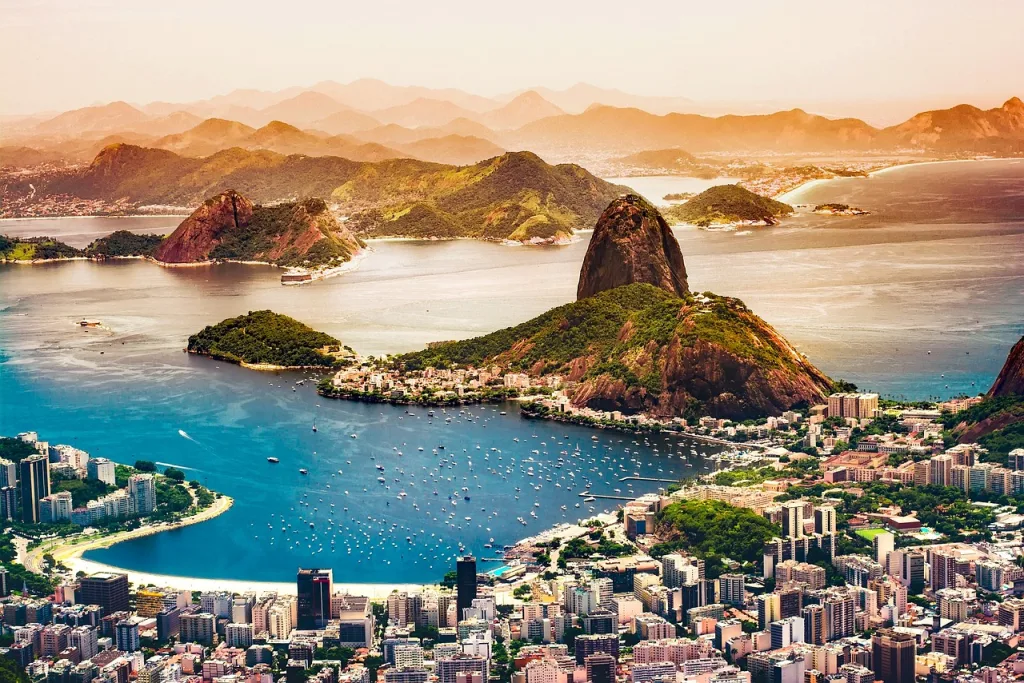
Sugarloaf Mountain—Pão de Açúcar—sits like a punctuation mark at the mouth of Guanabara Bay. From Copacabana and Ipanema, from the hills of Santa Teresa, from the deck of a ferry, that rounded granite peak announces Rio de Janeiro in a single, unforgettable silhouette. Visitors come for the view, photographers hunt for the perfect light, and climbers test their nerves on its exposed granite faces. But the mountain’s striking appearance is not an accident of scenery; it is the result of deep time, slow heat, and relentless water.
A stone with a long biography
To understand Sugarloaf’s origin, you must start far below the surface. The mountain is a resistant mass of intrusive igneous rock—primarily granite with veins of quartz—that crystallized from magma that cooled slowly beneath the Earth’s crust. That slow cooling produced large mineral grains and a very hard, coherent rock. This process happened long before the beaches and bays we now associate with Rio existed—during geological eras when continents were being built, broken, and stitched back together.
Granite bodies like Sugarloaf formed deep underground as part of a larger crystalline basement. Over hundreds of millions of years the crust experienced uplift and tectonic rearrangements that gradually pushed these once-buried rocks toward the surface. The most visible faces you see today only became exposed after long phases of erosion removed overlying, softer rocks and sediments. In plain terms: the mountain was born underground, rose up by geological forces, then was revealed by the patient work of erosion.
How erosion sculpted the loaf shape
Granite is tough, but it doesn’t simply stand untouched. Weathering operates at a variety of scales. Chemical weathering alters minerals along fractures, while physical weathering—temperature swings, salt from the sea, wind—loosens fragments. One characteristic process that helps produce Sugarloaf’s rounded, dome-like appearance is called exfoliation. Layers of rock peel off slowly along curved surfaces as the pressure of overburden is released and as temperature changes cause expansion and contraction.
Along the coastline, wave action and the alternation of sea levels intensified the sculpting. When the sea sat higher, waves undercut lower portions of the rock; when it fell, rainfall and runoff worked at exposed slopes. This combination of coastal erosion and the granite’s jointing pattern favored the formation of steep, smooth faces and the classic bulbous silhouette we now recognize.
Read the stone: features to look for up close
When you approach Sugarloaf—by foot along the Urca neighborhood or from the cable car—notice the texture. The rock’s surface often shows rounded cracks, smooth flanks, and polished patches where wind and sand have abraded the stone over centuries. You’ll spot veins of lighter quartz cutting through the darker granite and occasionally see small pockets where chemical weathering took a stronger hold. Those cracks and joints are not random; they record stresses the rock experienced while it was still buried and later during uplift. Climbers use those features as natural holds; geologists read them like pages in a history book.

Sugarloaf’s family: Morro da Urca, Corcovado, and the Tijuca Massif
Sugarloaf is not an island of rock in isolation. It belongs to a regional family of granite and gneiss outcrops that punctuate Rio’s landscape. Immediately adjacent sits Morro da Urca, lower and gentler, which together form the pair visitors cross with the famous cable car. Corcovado, where Christ the Redeemer perches, is a separate granite dome to the west, while the larger Tijuca Massif and surrounding hills carry related geologic histories. These features vary in height and shape because they experienced different histories of fracturing, uplift, and erosion, but all share a deep-time origin rooted in crystalline basement rocks.
How the coast and climate shaped the setting
Rio’s coastline has moved through time. Sea-level changes driven by ice ages and tectonic activity altered the shoreline and reshaped the relationship between land and water. When sea level was higher, wave action more aggressively clipped the coastal slopes; when it dropped, the exposed rock endured rain and biological weathering. The city’s tropical climate—rapid temperature changes from day to night, heavy seasonal rains, salty marine aerosols—has been a steady sculptor. The result is a distinct coastal granite landscape: rounded domes with steep faces overlooking blue water.
Names, sugar trade, and a shape everyone recognized
The name Pão de Açúcar—Sugarloaf—arrived with Portuguese colonial culture and the material reality of the sugar economy. In Europe and colonial Brazil, processed sugar was commonly sold in conical loaves that were wrapped and cut down to smaller portions at market. When settlers and sailors looked at the mountain’s tapered, conical mass rising at the bay’s entrance, the comparison was immediate. The name stuck, and the rock became a navigational landmark as well as a cultural emblem.
Human footsteps: cable car, climbing routes, and cultural life
The human relationship with Sugarloaf intensified with technological and recreational developments. The cable car system that carries visitors between Praia Vermelha, Morro da Urca, and Sugarloaf opened in the early 20th century and transformed access. From that vantage, the city’s layout—the crescent beaches, the bay, the serried hills—unfolds in layers. The cable car is now almost as iconic as the rock itself: a short ride, a long view.
Rock climbing became part of the mountain’s modern story. The granite faces offer excellent friction and cracks that make for trad and multi-pitch climbs. Routes range from approachable classics to demanding lines that test commitment and technique. Climbers worldwide come to experience both the ascent and the reward: a panoramic view over Rio unlike any other.
Nature’s island: biology clinging to granite
Granite outcrops like Sugarloaf support surprisingly resilient pockets of life. Soil accumulates in small depressions and cracks; seeds arrive by wind and birds; and plants adapted to thin soils take hold. You’ll find hardy shrubs, bromeliads clinging to rock crevices, and arthropods exploiting microhabitats. The surrounding waters and the nearby patches of Atlantic Forest add to ecological richness—birds ride thermal winds around the peak, and marine life in Guanabara Bay depends on coastal inputs. Though Sugarloaf itself is not a rainforest, it is a green island in a mosaic that includes the restored forests of Tijuca and the urban ecosystems of Rio.
Looking at the broader geologic map
Placing Sugarloaf within Brazil’s geology clarifies why the mountain is distinct from other scenic features. Much of Brazil’s interior is covered by ancient cratonic shields and sedimentary basins. Along the southeastern coast, however, these deep crystalline rocks meet the sea. Sugarloaf is a local expression of that meeting—an exposed block of crystalline basement left where softer surrounding materials eroded away. It’s not a volcano, nor is it simply a pile of rubble; it’s a coherent, once-buried rock mass that recorded conditions deep inside the Earth before being revealed to the sky.
Tips for visitors who want to read the mountain
Seeing Sugarloaf with geological curiosity deepens any visit. Start in Urca: walk along the shore at Praia Vermelha and observe the lower slopes—look for joint sets (visible as regular fractures) and color changes where quartz veins appear. Take the cable car at a less-crowded hour to watch the granite faces shift color with the sun. If you’re a climber, hire a local guide who knows current route conditions and access rules. Bring binoculars or a camera with a zoom lens to study exfoliation surfaces and the way plants colonize cracks. And if you time your visit for late afternoon, you’ll watch how the city and bay glow as the sun lowers—natural history and human history arriving at the same spectacle.

Conservation pressures and human impact
Like many natural landmarks near dense urban centers, Sugarloaf faces pressures. Tourist foot traffic, rock-climbing wear, and the broader environmental health of Guanabara Bay influence both the experience and the rock’s micro-ecosystems. Pollution and sedimentation in the bay alter coastal processes, while urban expansion increases runoff that affects erosion patterns on nearby slopes. At the same time, Rio has a strong cultural attachment to Sugarloaf. That attachment often motivates careful management: trail maintenance around the base, regulations on climbing routes, and educational signage for visitors. Respecting rules and following low-impact principles—stay on designated paths, avoid removing plants, and carry out all trash—helps keep the mountain recognizable for future generations.
Sugarloaf in photography, art, and popular imagination
Because the mountain is both accessible and photogenic, it is ubiquitous in representations of Rio. Photographers chase the light from sunrise at Copacabana to sunset along the bay. Artists paint the curve of the rock and its reflection in calm water. That visual currency reinforces the mountain’s role as a symbol: not simply a geologic object, but a shorthand for Rio’s combination of sea, stone, and city. When foreigners learn about Brazil, Sugarloaf often becomes a first image—a gateway to curiosity about urban ecology, colonial history, and Brazilian culture.
Combining a visit with Rio’s other stories
Keep perspective: Sugarloaf is a magnificent single landmark, but Rio’s story is written across many places. Pair a morning trip to Sugarloaf with a walk through Urca’s quiet streets and lunch at a seaside kiosk. Add an afternoon in Tijuca National Park to see how reforestation changed the city’s hydrology, or visit the historic center of Rio to understand how the bay shaped colonial trade. For travelers interested in geology, a trip to the nearby islands and the islands of Guanabara Bay reveals how the coastline and sea interact with the crystalline basement rocks.
Questions visitors often ask
Is Sugarloaf a volcano? No. Its origin is deep underground as an intrusive rock body that later became exposed; there’s no volcanic cone or recent magma activity tied to the peak. How old is it? The granite belongs to rocks that formed in very ancient geological periods—hundreds of millions of years ago—long before modern coastlines existed. Can you hike it? The classic public access route is via cable car, but local trails reach the base and nearby Morro da Urca. Rock climbing ascents are common, and certain routes require technical gear and experience. Is the view worth it? Absolutely—the vantage points reveal Rio’s layout in a way few other sites do, and the mountain’s position at the bay’s mouth offers dramatic perspectives.
What to notice that most people miss
Look for subtle markers of geologic process rather than searching for dramatic features. The way water stains streak the stone after rain. Tiny pockets where salts crystallize and then dissolve. Green patches of moss in shaded fissures. Little colonies of plants that survived decades of sun and wind. These are the signatures of ongoing weathering and life persisting on a very exposed substrate. They remind visitors that the mountain is not a static postcard; it’s a dynamic interface between rock, water, air, and living organisms.
Why the mountain matters beyond aesthetics
Sugarloaf’s importance extends past its beauty. Geologically, it’s a visible fragment of continental history anchored at the sea. Culturally, it tied into the sugar economy that shaped colonial Brazil and became a navigational reference for sailors arriving in Guanabara Bay. Ecologically, it supports microhabitats and contributes to the green-blue mosaic of Rio’s coastline. Politically and socially, it’s a public space that reflects how a city negotiates access, tourism, and conservation. All these threads—rock, commerce, recreation, ecology—intertwine in a single landmark.
How to tell friends back home about Sugarloaf
If you want to explain the mountain’s origin in one clear sentence: it’s a hard, ancient mass of granite that formed underground, was exposed by uplift, and was sculpted into a loaf-like dome by long-term weathering and coastal erosion. Add a human touch—mention the cable car ride, a café in Urca, the way light pools on Guanabara Bay at dusk—and you’ll give people not just a geological thumbnail but a sense of why locals love the place.
Final note for curious travelers
Approach Sugarloaf with both a camera and a sense of curiosity. Watch the layers of history: crystalline rocks formed deep in Earth, the colonial economy that named it, early cable cars that opened access, climbers who leave chalk on its cracks, and the shrubs that find purchase on tiny ledges. It is possible to enjoy the postcard view and, at the same time, read the mountain’s deeper story. For foreigners learning about Brazil, Sugarloaf offers an excellent primer: geology, coastal processes, urban culture, and the ways nature and people meet in a city that always seems to be changing.