
A country of extremes: why Brazil feels like several nations
Brazil stretches from the equator well into the temperate latitudes of the Southern Hemisphere. That span creates a patchwork of climates: steamy equatorial rainforests in the North, a sun-baked semi-arid interior in the Northeast, humid tropical coasts down the east, and cool, sometimes chilly winters in the South. If you land in Manaus and then travel to Porto Alegre a week later, you won’t just notice different weather — you’ll experience different light, food rhythms, and daily routines shaped by climate.
Latitude and the sun: the simplest explanation
Start with latitude. Areas closer to the equator receive more direct sunlight year-round. The sun’s rays strike those regions at a steep angle, concentrating energy and keeping temperatures consistently high. The North of Brazil sits at and around the equator. That means short seasonal swings in day length and consistent solar heating — a major reason cities like Belém and Manaus stay hot almost year-round.
Move south, and the sun becomes less direct during what we call the Southern Hemisphere winter. Southern Brazil is farther from the equator; seasonal changes in day length and solar angle are larger there. Winters are cooler, days shorter, and nights longer — all of which add up to a noticeably colder feel compared with the Amazon basin.
Rainforests package heat with humidity
The northern part of Brazil is dominated by the Amazon, the world’s largest tropical rainforest. The Amazon doesn’t just grow because it’s hot; it actively creates a humid, warm atmosphere. Trees release water vapor through evapotranspiration, which recycles moisture into the air and helps sustain regular cloud cover and frequent rains. That constant exchange of water and heat keeps daytime temperatures high and nights relatively warm, producing the muggy, heavy air visitors associate with jungle trips.
Because rain falls frequently and the canopy traps warmth, the Amazon region shows little temperature variation across the year. Rainy seasons do shift and river levels swing dramatically, but the overall thermal environment remains persistently warm — a contrast with the sharper seasonal temperature swings farther south.
Ocean currents and the meeting of seas
The oceans around Brazil play a subtler but crucial role. Off the eastern coast, the warm Brazil Current pushes southward along the continental slope. From the south, the cold Malvinas (Falklands) Current flows northward, and the two meet off southern Brazil. That collision zone brings cooler sea surface temperatures and stronger frontal activity near the southern coast than farther north, where the warm Brazil Current dominates.
Cooler coastal waters near the southern states amplify the feeling of cold on land because the sea helps moderate coastal temperatures and supports the passage of cold fronts. That’s one reason coastal cities like Porto Alegre and Florianópolis experience noticeable winter chills despite sitting on the Atlantic.
Polar air masses: when Antarctic cold arrives
Southern Brazil sits within reach of polar air masses moving north from Antarctica. These cold fronts sweep up the continent, bringing sharp drops in temperature and sometimes frost or even light snow in highlands. That flow of cold air is a major factor that sets the South apart from the rest of Brazil: while the North rarely sees temperatures below 20°C, the South routinely drops into single digits Celsius in winter.
Those polar incursions also create dramatic weather swings. You can wake up to a crisp, clear morning and by afternoon feel a warm sun return — a pattern familiar to residents of Rio Grande do Sul, Santa Catarina, and parts of Paraná.
Topography and altitude: cooler pockets in surprising places
Altitude cools. High plateaus and mountain ranges in Brazil create local climates that differ from nearby lowlands. Cities like Campos do Jordão and São Joaquim sit at elevations where winter nights are genuinely cold and snowfall has historically occurred. Even São Paulo, located at higher elevation than the coastal plain, often has nights that feel cooler than Rio’s.
Altitude matters for travel plans. A night in the Serra da Mantiqueira or Serra do Mar calls for warmer clothing, while the lowland coastal beaches remain comfortably warm most of the year. Elevation also affects rainfall patterns: windward slopes intercept moist air, producing microclimates that are wetter than nearby valleys.
Köppen climate snapshots: the country’s climate zones
A simple way to organize Brazil’s variety is through the Köppen climate classification system. The map looks like a patchwork: equatorial (A) climates blanket the Amazon; tropical savanna (Aw) covers a broad central belt including the cerrado and parts of Brasília; hot semi-arid (BSh) dominates large areas of the Northeast interior, the sertão; and temperate subtropical types (Cfa/Cfb) take hold in the South. Each of these zones brings distinct travel experiences and practical needs.
When planning trips, recognize these patterns: expect heavy, steady rains and deep humidity in the Amazon; intense dry spells and drought vulnerability in the sertão; a classic wet-dry cycle in the cerrado; and four-season variation with cool winters in the South.
How seasons work in Brazil — not what many visitors expect
Brazilians live by Southern Hemisphere seasons: summer runs from December through February, and winter from June through August. That timing is important for festival planning, wildlife viewing, and weather expectations. Carnival, for example, typically falls in late summer and is tied to warm-season travel rhythms, beaches and street celebrations.
But seasons don’t feel the same everywhere. Summer in the South brings long, warm days but also the occasional thunderstorm. In the North, seasonal shifts are more about wet and dry periods than cold and hot — rivers rise and fall, and access to floodplain islands or trails changes dramatically between seasons.
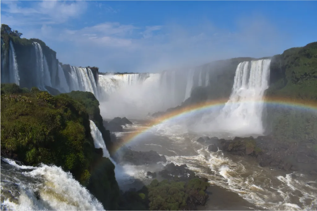
First image: seeing the Amazon’s atmosphere at work
Any journey into the Amazon reveals how landscape and weather marry: wide rivers reflecting dense canopy, sudden cloud buildups, and a steady humidity that colors every step.

Human impacts and regional differences in everyday life
Climate differences shape routines. In Brazil’s North, kitchens and public life adapt to heat and humidity: light clothing, siesta-like slow afternoons during the hottest hours, and architectural features that favor ventilation. In southern towns, stews, roasted meats, and heavier clothing make sense when August mornings bite with frost. Local festivals and agricultural calendars track these rhythms: harvests, cattle cycles, and religious festas align with the seasons unique to each region.
Urban design reflects climate too. Coastal northern houses often have verandas and high ceilings; in the South, insulation and double-glazing are more common in mountain towns. If you rent an Airbnb, notice these subtle cues — they tell you how locals live with their climate.
Health and safety: climate-driven precautions for travelers
When you travel in Brazil, climate shapes health advice. In Amazonia and many coastal regions, mosquitoes are active year-round; carry repellent and consider long sleeves during dusk and dawn. Yellow fever vaccination is commonly recommended for travel to parts of the Amazon and some rural areas — check official travel health guidance before you go. Heat and sun exposure in the North demand sunscreen and hydration, while cold snaps in the South require warm layers and a plan for sudden temperature drops.
Another travel reality: road and river access change with seasons. Heavy rainfall can make dirt roads impassable and swell rivers, altering itineraries in the Amazon and Pantanal. In the sertão, long dry seasons may limit water availability. Always consult local operators and be flexible.
Practical packing: what to bring for North versus South
Packing for Brazil means choosing by region, not a single “Brazil wardrobe.” For the North and Amazon: breathable, quick-dry clothing, a long-sleeve shirt for mosquito protection, good walking sandals or waterproof shoes, high-SPF sunscreen, a hat, and a light rain jacket. A small dry bag for electronics is essential on river excursions.
For the South: layers. Bring a warm jacket, thermal base layers if you plan mountain hikes, and a compact umbrella. If you visit between June and August, include a hat and gloves for early mornings in highland towns. City smart-casual will cover most evenings; if you attend formal events in São Paulo or Porto Alegre, one smarter outfit will do.
Weather systems that change plans: El Niño, La Niña, and frontal variability
Large-scale patterns like El Niño and La Niña shift rainfall and temperature across Brazil. These ocean-atmosphere phenomena redistribute moisture and can make parts of the country wetter or drier than usual. Their effects are complex and vary by region and season, but they’re part of why one year’s Amazonian rains or sertão droughts may look very different from another year’s.
Short-term frontal systems — the cold snaps from the south — are easier to watch in forecasts. Travelers interested in seeing southern snowfall or crisp highland mornings should track synoptic forecasts a few days ahead and accept that weather can change quickly.
Second image: southern Brazilian winter streetscape
Southern cities and mountain towns show a very different face: tree-lined streets with people in jackets, mist rolling off lagoons, and stone-built cafés that invite you to linger with warm coffee.
Culture through a climatic lens: food, festivals, and architecture
Climate influences what people eat and celebrate. In the Amazon and along the northern coast, fish and river-based dishes dominate; tropical fruits and manioc are staples. The Northeast sertão developed grilled meats and hearty stews suited to dry conditions. Southern states, with cooler winters and strong European immigration, feature baking traditions, smoked sausages, and festivals like Oktoberfest in Blumenau, where cooler, autumnal weather feels right for beer halls and layered clothing.
Architectural responses also tell a story: colonial towns in the Northeast use thick walls and shaded courtyards to keep interiors cool, while southern houses may incorporate steeper roofs and better insulation for rain and cold.
How climate shapes travel timing and wildlife viewing
Pick the right season and your Brazil trip improves dramatically. In the Pantanal, the dry season concentrates wildlife around shrinking pools, making sightings easier. In the Amazon, river levels determine what you can access — low water opens riverbanks and oxbow lakes, while high water turns forest trails into canoe routes. For the South, winter is best for experiencing cool-weather festivals or the rare chance of snow in mountain towns; summer offers beach days and long daylight hours.
Birdwatchers, anglers, and photographers should coordinate with local operators who understand these seasonal windows. They’ll advise when access is safe and wildlife is most visible.
On-the-ground tips for staying comfortable
Carry a small medicine and repair kit. Mosquito repellent, a reusable water bottle, SPF lip balm, and blister plasters save a lot of trouble. In the North, invest in good insect protection for night-time forest lodges; in the South, pack a compact thermal layer for sudden cold fronts. Check whether lodgings provide mosquito nets, and always verify the availability of potable water if you are off-grid.
Transportation is weather-sensitive. River transport dominates in the Amazon, so delays are common when water levels change. In the South, fog and winter storms occasionally slow flights and road travel. Build buffer days into tight itineraries.
Sample itineraries that show the contrast
If you have two weeks and want to taste both sides of Brazil’s climate: spend the first week in the North — base in Manaus, day trips into the flooded forest (igapó) or solid-ground reserves, evenings tasting regional fish stews and castanhas (Brazil nuts). Spend the second week in the South — Porto Alegre and a side trip to São Joaquim or Gramado to feel alpine-like air, try churrasco (barbecue), and walk parks that show off fall or winter foliage.
If your interest is wildlife and nature: plan according to water cycles. Visit the Pantanal in the dry season for high wildlife concentration. Travel the Amazon just after the peak of high water if you want canoe excursions among the forest tops; go in the low-water season to see riverbanks and trails up close.
Practical resources and local weather literacy
Useful tools: Brazilian meteorological services (INMET), regional weather apps, and local operator advisories. Weather language matters — learn a few Portuguese phrases like “frente fria” (cold front) and “estação chuvosa” (rainy season) to understand local announcements. Local tourism offices often have up-to-date notes on road and river conditions, and national health sites will list vaccination recommendations and current advisories.
One last travel-minded observation
Brazil’s climate diversity is part of its appeal. The country lets you move from tropical riverboats to snowy highland towns within days. That variety demands flexibility from travelers: adapt your wardrobe, allow extra transit time during seasonal extremes, and tune into local advice. With that approach you’ll experience not only different weather, but distinct local cultures shaped by their climates — and that’s the real richness of traveling through Brazil.